Utility Mapping Support
Accurate pot holing and service verification to support utility surveys, PAS 128 programmes, and pre-construction design.
What Is Utility Mapping Support?
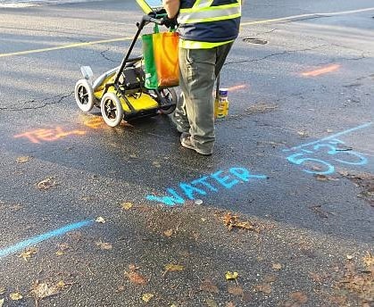
Utility mapping is the process of identifying, locating, and recording the position of buried services to inform design and construction decisions. Vacuum excavation plays a critical role in this process, providing the physical verification that geophysical surveys and utility records alone cannot deliver. AVAX works alongside utility surveyors, design engineers, and project managers to provide accurate, safe pot holing as part of structured mapping programmes.
How It Works
PAS 128, the British Standard for utility surveys, defines four quality levels of survey, from desktop research through to physical verification by excavation. Quality Level A, the highest standard, requires buried services to be physically exposed and their position accurately recorded. This is where vacuum excavation is essential. Without physical verification, even the most thorough geophysical survey carries residual uncertainty that can translate into risk on site.
AVAX provides pot holing support to utility surveyors, civil engineers, and contractors carrying out PAS 128 surveys and pre-construction utility investigations. Our operators work methodically to expose services at designated locations, allowing surveyors to record accurate position, depth, and condition data. We can work to a structured programme across large sites or respond quickly to individual verification requirements.
This service is particularly valued on major infrastructure projects, including road schemes, rail works, utility diversions, and large development sites, where the consequences of inaccurate utility data can be severe. Thorough pre-construction mapping backed by physical verification helps project teams reduce risk, improve programme certainty, and avoid the delays that come with unexpected service encounters.
Key Benefits
Provides Quality Level A verification for PAS 128 utility surveys
Removes residual uncertainty from geophysical survey data
Accurate position, depth, and condition data for design purposes
Reduces risk of service strikes during construction
Supports confident design and programme planning
Works alongside your survey contractor or design team
Structured programmes across large sites or individual holes
Fast mobilisation to keep survey programmes on schedule
Why Vacuum Excavation Is Safer Than Traditional Methods
Traditional mechanical excavation, whether by machine or hand, carries a real risk of striking buried utilities. Cables, pipes, and ducts are often inaccurately mapped or not recorded at all. One service strike can cause serious injury, significant delays, and disruption to essential services including gas, electricity, water, and telecoms.
Vacuum excavation removes material using controlled suction. Operators can expose buried services without any mechanical contact with the ground, and the process can be stopped immediately if a service is encountered. It is the preferred method across utilities, infrastructure, and construction wherever work is taking place near buried assets.
For contractors and project managers, vacuum excavation also reduces liability. It demonstrates a commitment to safe working practices and compliance with industry guidance, including PAS 128 and the HSE requirements for working near buried services.
Typical Applications
- PAS 128 Quality Level A utility surveys
- Pre-construction utility investigation programmes
- Service verification on major infrastructure projects
- Road and highway design support
- Rail infrastructure pre-construction surveys
- Utility diversion design support
- Large development site utility mapping
- Verification of geophysical survey results
- Condition assessment of existing buried assets
- Supporting ground investigation programmes
Industries We Work With
Our utility mapping support service is used across a wide range of sectors throughout the UK.
Why Choose AVAX?
Safe excavation around live services
Our vacuum excavation method removes material without any mechanical contact with buried utilities, protecting your team, the public, and essential services.
Experienced operators
Our team brings genuine site experience across utilities, infrastructure, and construction projects throughout the UK.
Modern, well-maintained fleet
We operate four suction excavation units and continue to invest in our equipment as the business grows.
24/7 availability
We are available around the clock for urgent and emergency works, with fast mobilisation across our operating area.
Areas We Cover
We operate across the UK. Here are some of the key areas where we regularly carry out utility mapping support projects.
View all areas we cover →Frequently Asked Questions
What is PAS 128 and how does vacuum excavation support it?
PAS 128 is the British Standard for underground utility surveys. It defines four quality levels, with Quality Level A being the highest. Quality Level A requires physical verification by excavation, and vacuum excavation is the recommended method for this, as it safely exposes services without risk of damage and allows accurate position and depth data to be recorded.
Can AVAX work alongside our utility survey contractor?
Yes. We regularly work alongside utility surveyors, geophysical survey teams, and design engineers as part of structured mapping programmes. We can coordinate directly with your survey contractor to ensure pot holing is carried out at the right locations and to the required standard.
How many pot holes can you complete as part of a mapping programme?
Output depends on site conditions, access, and the depth and size of each excavation. For a typical programme of shallow pot holes in accessible ground, we can achieve 8 to 15 holes per day. We will provide a realistic programme estimate based on your specific requirements.
Do you provide records of the services exposed during mapping?
Our operators can record the position, depth, and condition of exposed services. For formal survey records as part of a PAS 128 programme, we recommend working alongside a qualified utility surveyor who can produce the required documentation. We can provide supporting information to assist with this.
What areas do you cover for utility mapping support?
We carry out utility mapping support across the UK, with regular projects in London, Hertfordshire, Bedfordshire, Cambridgeshire, Northamptonshire, Oxfordshire, and the wider South East and East of England. Contact us to discuss your programme and confirm availability.